Suggestions for comments to Planning and Elected Officials:
Address the impact of the proposed development adding more than 300 people, 200 cars, pedestrians/bicycles, additional 1100+ cars daily, (not counting delivery trucks, service trucks, visitors, walkers) on Coles Road, well water capacity, WWTP capacity, the Maxwelton watershed, building over an identified critical aquifer recharge area, crowded intersections, development residents wandering on private property, increase in crime, few $25 hr+ jobs available, loss of rural environment, modification of critical slopes, removal of trees, wetlands contamination, affordable housing units occupied by other than S. Whidbey residents, occupants of the ‘50%’ provided affordable subsidized rentals have little discretionary income, traffic jams into and out of Langley, etc. Recommend an appropriate amount and type of housing units the parcel and local road can support (2005 MOU for the 24 home agreement protected much of the parcel for public and private trails).
From Developer’s Application: “1. That the “city” and its neighborhoods are arranged to reduce automobile use (requires a vehicle for transportation)
2. That areas of current and future hazard remain or become undeveloped to avoid unnecessary loss of life (except for variances)
3. That the regional watershed is protected to preserve the future water supply (for the Langley wellhead). 4. That critical areas are protected and enhanced (definition of critical area not included)


City Of Langley Planning Department
The application package is available for review at https://langleywa.org/departments/community_planning_and_building_department/development_applications/coles_valley.php
What You Can Do
14 day comment period begins once the city accepts the application. Letters or emails addressing the impact of the development should be addressed to planning@langleywa.org Request your comments are sent to the hearing examiner
council@langleywa.org
Mayor@langleywa.org
Letters to various newspapers, news stations, environmental groups, citizens of Langley will bring awareness to the environmental loss, social challenges of the proposed development.
The public can submit comments at any point during the application review, and all comments will be put into the record.
14 days is the minimum amount of notice we have to provide to receive comments, but we will continue to accept them before and after that, until the date of the public hearing.
Send comments to the above City of Langley emails (Planning Department and elected officials).
Notify neighbors and friends on South Whidbey to review the SWLLC application and send comments.


Los Angeles - Ethics Demand to City article

Developers and their special interest lobbyists must no longer be permitted to choose the consultants who literally write Environmental Impact Reports for their own developments. This obvious conflict of interest must be banned so that the actual environmental impact – not a consultant’s self-interested twisting of traffic, health, parking, open space and density impacts – will be fully mitigated, instead of ignored.

— There must be a clear and transparent process, including fast-tracked deadlines, for crafting the new Los Angeles General Plan that empowers the people to chart the future of our own city, slashing the undue influence of developers and their lobbyists over the L.A. River, neighborhood character, mansionization, small lot subdivisions and other crucial public concerns.

— Spot zoning exceptions to the General Plan, a practice which currently allows wildly inappropriate mega-developments in cherished neighborhoods, must become the rare exception to the rule, rather than routine, as it is today.

— Ex parte communications between developers and city elected officials or members of the City Planning Commission — also known as backroom meetings — must be eliminated. Just as we have seen with the California Coastal Commission, ex parte communications give developers an all-access pass to our government officials while regular people with a much bigger stake in their communities wait in line at long meetings for one minute of public comment. We are better than that.

It is our hope that we can put aside special interest politics and rally around a shared vision for our collective future that serves all the unique neighborhoods and communities of Los Angeles.

Coalition to Preserve L.A. is a citywide movement of concerned residents who believe in open government, people-oriented planning, equitable housing and environmental stewardship of Los Angeles through advocacy and empowering the community.
http://preservela.wpengine.com/category/fight-back/
Brief Overview
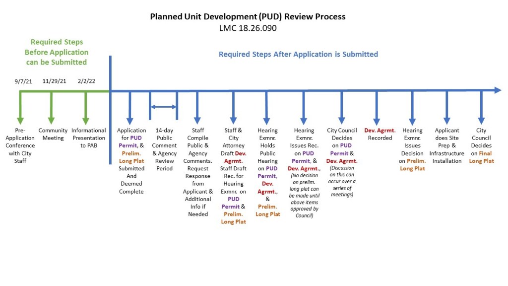
August 24, 2022 – SWLLC/Blossom Management submitted a development application to the City of Langley for ~28 acres near 5501 Coles Road. The proposal lists 161 rental apartments, townhouses, petite houses, homes with ADU’s, and additional commercial buildings divided into seven subplot’s to sell to various developers. The clock is ticking. The city did return the application to SWLLC for minor fixes Sept. 21.

1988– Gordon Iverson, Manager Georgia Pacific (cousin of Trillium CEO David Syre), helps divest GP of a small part of its holdings. It sold ~17,000 acres in 5 northwest Washington counties to Trillium Corp. 2500 – 3000 of those acres were on South Whidbey Island, in 28 separate parcels ranging in size from 20 to 780 acres. Trillium clear cut the Coles Road parcel first prior to deforesting other acreage on Whidbey. The Whidbey Environmental Action Network (WEAN) was born.
2002– NJB development (Nicole Terpsra, Jeff Johnson and Bob Libold- prior Trillium)) realizes Island County residences are 1 per 5 acres, turns to city for increased housing units.
2003-2006 Langley Annexation and plan to develop 24 homes with most of topography left intact approved. NJB abandons partially cleared land when city council refuses increase to 46 homes.
2010– Bob Libold and Ken Hertz form South Whidbey LLC, (a Bellingham, WA company). Libold’s Pacific Crest Partnership (Libold) sells the 40 acres for $10 to SWLLC for $10.
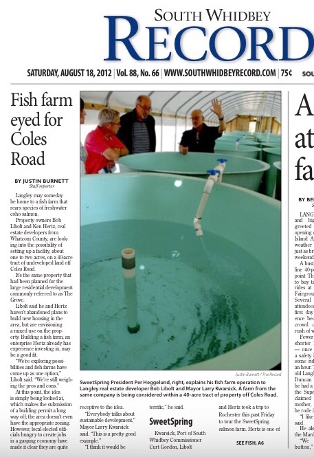
2012– SWLLC meets with city to operate a fish farm on 1-2 acres. Hertz has experience investing in fish farms. “We’re exploring possibilities and fish farms have come up as a possibility” Libold said. Mixed use residences are a possibility on the parcel.
2013– SWLLC and Ross Chapin propose a ~113 home PUD to city staff. Information on Hertz Blossom Management website states they expect PUD approval in 2015.
2016/17– SWLLC and Ross Chapin work with Langley Planning Director to energize city into building affordable housing units.
2019– city signs MOU with SWLLC and Langley mayor, begins writing new zoning ordinances and codes for multifamily infill at Coles Valley PUD with staff paid by the developer.
2021– City notified public of zoom presentation regarding Coles Road Parcel.
2022- second public presentation on zoom by PAB.
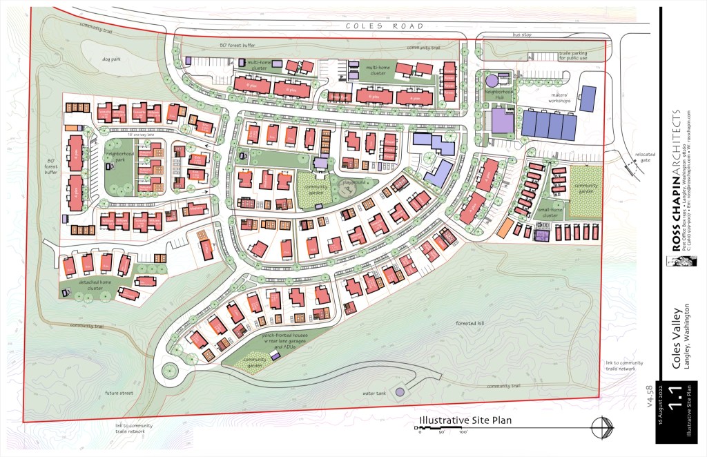

Once approved by the Langley City Council, the developers plan to grade the parcel, then immediately construct water, sewer, and roads. A water tower of unknown size, placed above the development, will provide water from the city well in Langley.
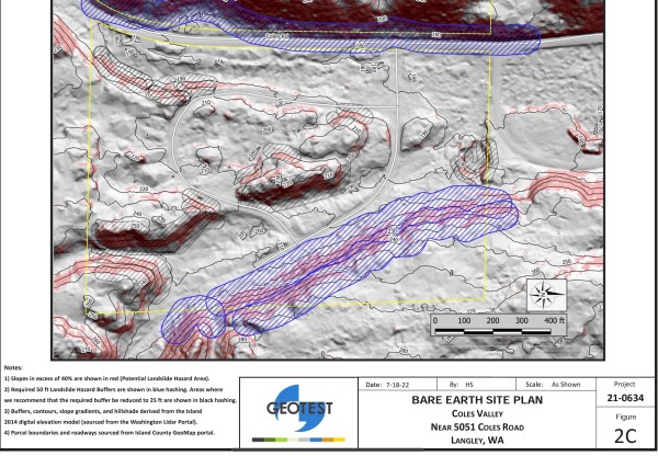
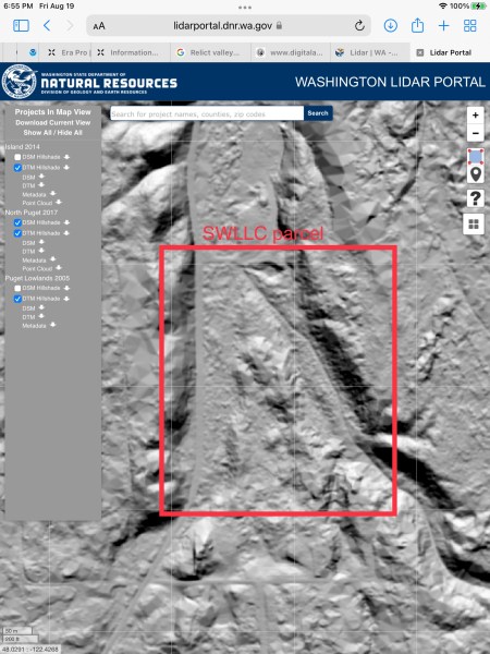
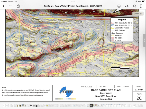
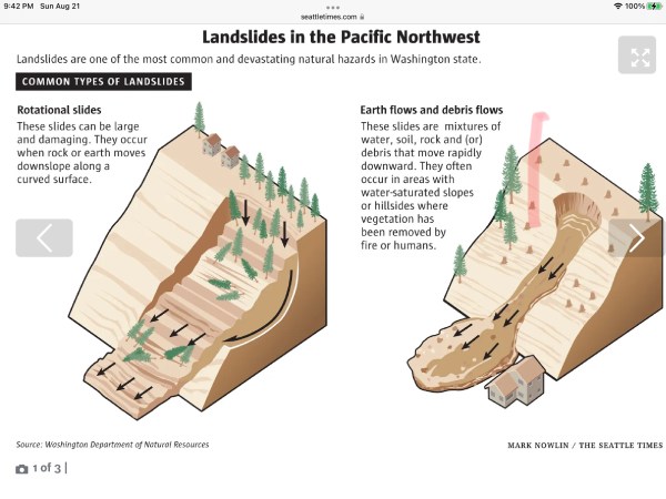
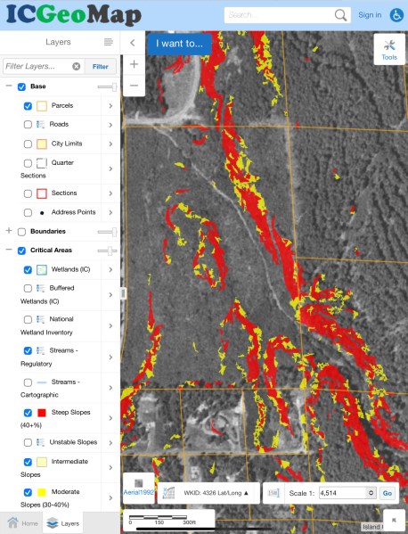
The actual of elevation of the parcel critical slopes and valley areas need to be surveyed vs reviewing online images. The “thumb feature” is 270 feet high vs 250 feet. The parcel slopes are sand and glacial till of unknown makeup. Modifying slopes for development is a leading cause of landslides in PNW.
The loss of mature or at least well-established trees has a significant effect on the stability of already marginal slopes. Soil disturbance and the further loss of young trees and brush, as well as the forest floor duff and litter, can further degrade stability. Log removal efforts can seriously disrupt shallow soils and such ground cover. Two major options: leave the trees where they fell or remove them. Either choice can impact slope stability and legal liability. Logs can be removed with little or no further disturbance of soil and ground cover by what loggers and commercial foresters call “full suspension” techniques.
Logs are lifted, not dragged. This requires specialized heavy equipment both at the top and bottom of a slope (or at least a strong “block” or pulley with a massive anchor at one end). Full suspension can also be achieved by balloons or large helicopters. The ‘reach’ of a crane from the top or from the base of a bluff is limited, even where such sites are accessible; they are almost useless on bluffs in the 150- to 300-ft range.

2018 Langley Water System Plan and Water Demand Forecast– commercial growth will decline, homes used occasionally could be sold to permanent residents. The estimate is a total population growth of 126 over seven years and 21 annual added housing units (petite to 3bed 3bath).
Prepared by Donald H. Gray
July 2009
EFFECT OF WOODY VEGETATION REMOVAL ON THE HYDROLOGY AND STABILITY OF SLOPES
One way to settle the argument about the effect of woody vegetation on the hydrology and stability of slopes is to cut down all the trees and see what happens. The effects of wide spread vegetation removal on the stability of natural slopes have been studied extensively as a result of a timber harvesting practice known as clear-cutting. It is useful and instructive to examine the consequences of such a practice vis a vis a policy promulgated and now being carried out by the US Army Corps of Engineers to remove all woody vegetation over 2 inches in diameter growing on or near the toe of earthen embankments or levees.
Widespread removal (clear-cutting) of trees on natural slopes and streambanks generally leads to an increase in slope failures. This is the overwhelming consensus of papers published in the scientific and technical literature as documented in the attached literature review. In some cases there may be a short- term benefit from tree removal resulting from a decrease in shear forces transmitted to a slope from wind. The adverse effect of wind depends, however, on such factors as the size and height of the canopy, stand density, and wind direction. The presence of tall, rigid trees growing near the water line of levees may also promote scour erosion around the base of the tree. These offending trees can be identified, selectively removed and/or pruned as part of an alternative vegetation management policy.
In the long run, cutting of trees on slopes leads to a gradual decrease in mass stability as a result of the decay of roots which previously acted as tensile reinforcements in the slope. Root decay can also lead to the formation of pipes in a slopes which promote internal or seepage erosion. The removal of tree canopy results in the loss of interception and evapo-transpiration which tends to promote wetter and less secure slopes. Canopy removal also results in less attenuation in the delivery rate of rainfall to the ground surface
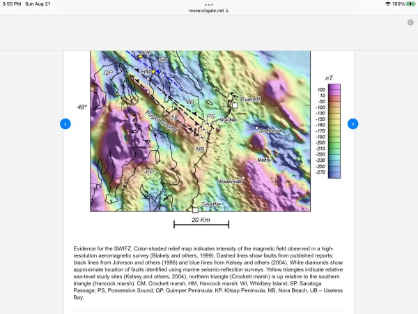
Water Resources of Island County
Water resources are critically important to the residents of Island County. The availability of safe drinking water is an issue that will guide Island County’s growth, development, and resource protection measures into the future.
Groundwater is Island County’s main water source. Seventy-two percent of Island County residents rely on groundwater. As such, groundwater quantity and quality are the driving reasons for our water resource management efforts.
Island County’s groundwater geology is highly complex. Its aquifers are made up of multiple layers of unconsolidated sand and gravel capable of supplying water to wells. Mixed between these aquifers are layers of silt and clay that pass water more slowly (aquitards). From place to place in Island County, aquifers and aquitards vary in thickness, width, and depth below surface (see Figure 1). There may also be several aquifer layers present, each with different characteristics (recharge, pressure, capacity, etc.).
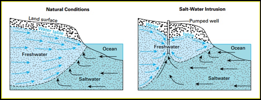
Islands in marine waters pose unique challenges for groundwater management. All of Island County’s groundwater aquifers are recharged only by rainfall infiltrating through land surfaces. Due to the rain-shadow effect of the Olympic Peninsula Mountains, areas of Island County vary in precipitation from 17 inches to 40 inches annually (see “Island County Annual Precipitation Map”, Appendix I). Some of the county’s aquifers (such as those at or below sea level near the shorelines) are connected to the saltwater of Puget Sound. Portions of these aquifers may contain saltwater. Seawater intrusion, the movement of marine saltwater into freshwater aquifers, is a serious issue in some areas of the county.
Will We Have Enough Water?
As water supply needs increase, it will be increasingly important for Island County residents to live within their water supply “means.”
The variability and complexity of our groundwater geology makes the question of, “how much water do we have?,” difficult to answer. Water resource management on islands requires very good information and detailed review at a small scale.
Groundwater Recharge
Groundwater recharge or the rate at which aquifers are replenished is one of the most difficult components of the water budget to quantify. Recharge rates are impacted by the amount and intensity of precipitation, soil and vegetation types, geology and topography. Recharge rates are highly variable in space and time. Global synthesis of recharge estimates revealed that after precipitation, vegetation type is the second most important factor controlling recharge rates (Kim and Jackson, 2012).
Recharge is viewed as the sum of several distinct flow pathways, including mountain system recharge that consists of mountain block recharge (lateral subsurface flow from mountains to valley aquifers) and mountain front recharge (infiltration of mountain stream runoff) (Wilson and Guan, 2004), diffuse recharge (direct infiltration of precipitation to basin floor), and focused recharge as a result of streamflow infiltration from ephemeral channels and/or perennial surface water bodies (Hogan et al., 2004). Recharge estimation methods can be classified into three main types depending on the source of data used to estimate recharge including surface water and water in the unsaturated and saturated zones (Scanlon et al., 2002). Providing robust recharge estimates is important for sustainable management of groundwater resources and estimating the groundwater footprint, defined as the required area to sustain groundwater dependent ecosystems and groundwater use (Gleeson et al., 2012).
Significance − rationale for assessment: The water stored in river and lake marginal wetlands from overbank flooding or slope run-off may percolate downwards into groundwater aquifers. This can replenish groundwater resources, maintain groundwater-dependent wetland ecosystems in discharge areas, or maintain base flow in rivers fed by discharge elsewhere.
Groundwater discharge
For the Groundwater recharge function to occur the following conditions must be met:
The HGMU must receive significant water inputs either from run-off or from overbank flooding. If the only inputs are from rainfall it is unlikely that recharge will occur at higher rates than in non-wetland areas.2.
Prior to water input, the water table must be sufficiently low to allow standing water to infiltrate the soil before it evaporates or runs off.3.
The HGMU must connect to an aquifer by means of a hydrological pathway. This usually means the HGMU must overlie the aquifer and not be separated from it by deposits of low permeability.4.
There can be no groundwater discharge.
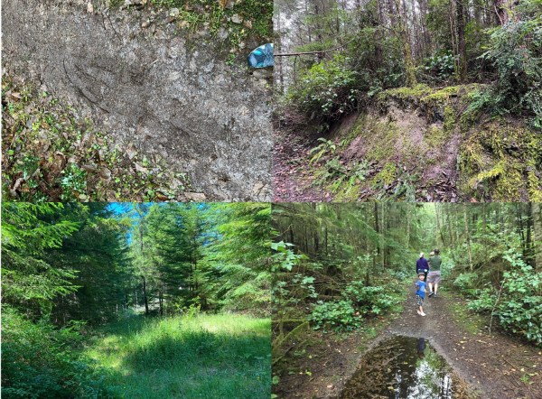
Forested areas around parcel are saturated much of the year
“Soil is more than just a substrate we walk on; it supports life. It provides essential nutrients, plays an important role in carbon and nitrogen cycles, and is home to a multitude of organisms that help decompose organic matter. When soil has been saturated by water, seasonally or year-round like those in wetland habitats, resulting in anaerobic, or low-oxygen, conditions, it is considered hydric”.
Hydrologic process are the main determinants of the type of wetland located on a site. Precipitation, groundwater, or flooding interact with soil properties and geomorphic setting to yield a complex matrix of conditions that control groundwater flux, water storage and discharge, water chemistry, biotic productivity, biodiversity, and biogeochemical cycling. Hydroperiod affects many abiotic factors that in turn determine plant and animal species composition, biodiversity, primary and secondary productivity, accumulation, of organic matter, and nutrient cycling.
Because the hydrologic regime has a major influence on wetland and aquifer functioning, understanding how hydrologic changes influence ecosystem processes is essential, especially in light of the pressures placed on remaining wetlands by society’s demands for water resources and by potential global changes in climate. USGS website
